Geolocate

Newburg topographic map

Click on the map to display elevation.

About this map

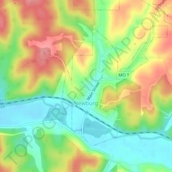
Name: Newburg topographic map, elevation, terrain.

Location: Newburg, Phelps County, Missouri, United States (37.90744 -91.91201 37.92635 -91.88640)

Average elevation: 256 m

Minimum elevation: 211 m

Maximum elevation: 307 m

Other topographic maps

Click on a map to view its topography, its elevation and its terrain.

Jerome

United States > Missouri > Phelps County

Average elevation: 243 m

Gear up for your next adventure:

🥾Mountain Trail Shoes - High-traction shoes for mountain trails
💡LED Headlamp - Hands-free illumination for night hiking and camping
🥾Mountain Hiking Shoes - Shoes with superior grip for mountainous terrain
🛶Kayak Accessories - Essential gear for safe and fun kayaking adventures
🥾Mountaineering Boots - Supportive boots for climbing and high-altitude hiking

As an Amazon Associate, this site earns from qualifying purchases at no extra cost to you.