
Make a donation
Gear up for your next adventure:
As an Amazon Associate, this site earns from qualifying purchases at no extra cost to you.
Windber topographic map
Click on the map to display elevation.
Make a donation
Gear up for your next adventure:
As an Amazon Associate, this site earns from qualifying purchases at no extra cost to you.
About this map
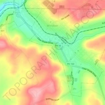
Name: Windber topographic map, elevation, terrain.
Location: Windber, Somerset County, Pennsylvania, 15963, United States (40.21890 -78.84394 40.24479 -78.80358)
Average elevation: 560 m
Minimum elevation: 484 m
Maximum elevation: 625 m
Make a donation
Gear up for your next adventure:
As an Amazon Associate, this site earns from qualifying purchases at no extra cost to you.
Other topographic maps
Click on a map to view its topography, its elevation and its terrain.
Flight 93 National Memorial
United States > Pennsylvania > Somerset County > Stonycreek Township
Average elevation: 729 m
Barronvale
United States > Pennsylvania > Somerset County > Middlecreek Township
Average elevation: 604 m
Make a donation
Gear up for your next adventure:
As an Amazon Associate, this site earns from qualifying purchases at no extra cost to you.
Tire Hill
United States > Pennsylvania > Somerset County > Conemaugh Township
Average elevation: 466 m
Make a donation
Gear up for your next adventure:
As an Amazon Associate, this site earns from qualifying purchases at no extra cost to you.
2768 feet
United States > Pennsylvania > Somerset County > Jefferson Township
Average elevation: 811 m