
Fairmount topographic map
Click on the map to display elevation.
About this map
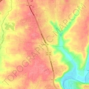
Name: Fairmount topographic map, elevation, terrain.
Average elevation: 198 m
Minimum elevation: 144 m
Maximum elevation: 222 m
Other topographic maps
Click on a map to view its topography, its elevation and its terrain.
Iroquois Park
United States > Kentucky > Jefferson County > Louisville > Parkwood
Average elevation: 167 m
E.P. "Tom" Sawyer State Park
United States > Kentucky > Jefferson County > Louisville > Lakeland
Average elevation: 209 m
E.P. "Tom" Sawyer State Park
United States > Kentucky > Jefferson County > Louisville > Lakeland
Average elevation: 209 m