
Make a donation
Gear up for your next adventure:
As an Amazon Associate, this site earns from qualifying purchases at no extra cost to you.
Heersum topographic map
Click on the map to display elevation.
Make a donation
Gear up for your next adventure:
As an Amazon Associate, this site earns from qualifying purchases at no extra cost to you.
Heersum
Heersum liegt im Innerstebergland – knapp 12 km südöstlich des Stadtzentrums von Hildesheim. Im Tal der Innerste befindet es sich am Südhang des Höhenzugs Vorholz (243 m), nördlich dessen sich die Hildesheimer Börde erstreckt. Jenseits des die Ortschaft im Süden passierenden Flusses liegen die Sauberge (317 m). Nachbarorte abwärts betrachtet entlang der Innerste sind Astenbeck im Osten und Listringen im Westen.
Make a donation
Gear up for your next adventure:
As an Amazon Associate, this site earns from qualifying purchases at no extra cost to you.
About this map
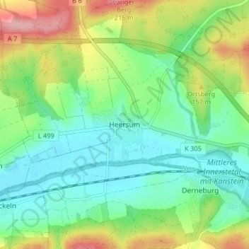
Name: Heersum topographic map, elevation, terrain.
Average elevation: 130 m
Minimum elevation: 85 m
Maximum elevation: 221 m
Make a donation
Gear up for your next adventure:
As an Amazon Associate, this site earns from qualifying purchases at no extra cost to you.
Other topographic maps
Click on a map to view its topography, its elevation and its terrain.