
Hermitage topographic map
Click on the map to display elevation.
About this map
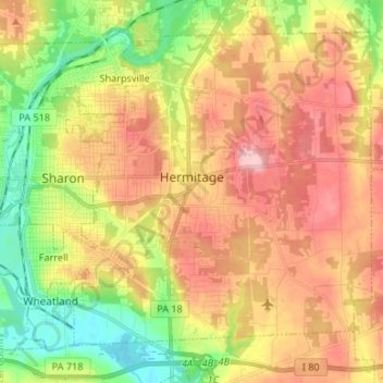
Name: Hermitage topographic map, elevation, terrain.
Location: Hermitage, Mercer County, Pennsylvania, United States (41.18733 -80.51920 41.27127 -80.38612)
Average elevation: 320 m
Minimum elevation: 247 m
Maximum elevation: 389 m
Other topographic maps
Click on a map to view its topography, its elevation and its terrain.
Little Shenango Dam
United States > Pennsylvania > Mercer County > Perry Township
Average elevation: 374 m
Schollard
United States > Pennsylvania > Mercer County > Springfield Township > Leesburg
Average elevation: 379 m