Geolocate

Woodland topographic map

Click on the map to display elevation.

About this map

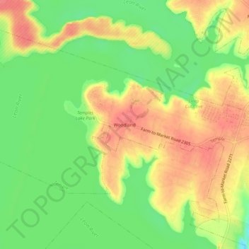
Name: Woodland topographic map, elevation, terrain.

Location: Woodland, Temple, Bell County, Texas, United States (31.11129 -97.50946 31.15129 -97.46946)

Average elevation: 191 m

Minimum elevation: 158 m

Maximum elevation: 220 m

Gear up for your next adventure:

🧼Travel Hand Sanitizer - Keep hands clean when water is scarce
👟Sport Hiking Sandals - Breathable footwear for water crossings and camp rest
💧Hydration Bladder - Hands-free hydration solution for long treks
🕶️Polarized Sunglasses - Reduces glare from snow and water at high elevations
🧥Packable Rain Jacket - Breathable waterproof layer for unpredictable weather

As an Amazon Associate, this site earns from qualifying purchases at no extra cost to you.