
Make a donation
Gear up for your next adventure:
As an Amazon Associate, this site earns from qualifying purchases at no extra cost to you.
Col de Joux topographic map
Click on the map to display elevation.
Make a donation
Gear up for your next adventure:
As an Amazon Associate, this site earns from qualifying purchases at no extra cost to you.
Col de Joux
De Col de Joux is een 1640 meter hoge bergpas die de verbinding vormt tussen Saint-Vincent in het Aostadal en Brusson in het Val d'Ayas. De pashoogte is een dichtbebost zadel tussen de Mont Dzerbion (2722 meter) in het noorden en de Testa di Comagna (fr. Tête de Comagne - 2099 meter) in het zuiden. Op de hellingen van deze laatste berg wordt in de winter volop geskied.
Make a donation
Gear up for your next adventure:
As an Amazon Associate, this site earns from qualifying purchases at no extra cost to you.
About this map
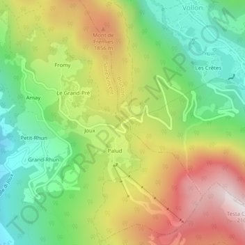
Name: Col de Joux topographic map, elevation, terrain.
Average elevation: 1,580 m
Minimum elevation: 1,188 m
Maximum elevation: 2,092 m
Make a donation
Gear up for your next adventure:
As an Amazon Associate, this site earns from qualifying purchases at no extra cost to you.