Geolocate

Tual topographic map

Click on the map to display elevation.

About this map

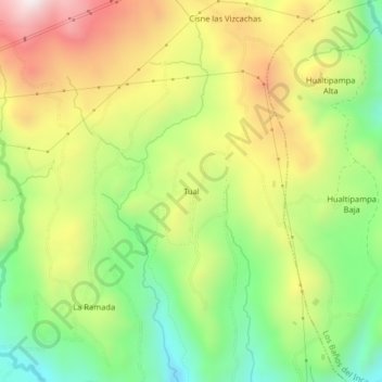
Name: Tual topographic map, elevation, terrain.

Location: Tual, Cajamarca, Perú (-7.08516 -78.57573 -7.04516 -78.53573)

Average elevation: 3,402 m

Minimum elevation: 3,066 m

Maximum elevation: 3,811 m

Other topographic maps

Click on a map to view its topography, its elevation and its terrain.

Río Mashcón

Perú > Cajamarca > Cajamarca

Average elevation: 2,905 m

Gear up for your next adventure:

🚑Survival Whistle - Signal for help across long distances in mountains
🌡️Emergency Mylar Blankets - Compact thermal protection for unexpected nights outdoors
🚲Handlebar Phone Mount - View topographic-map.com live while cycling
🧥Waterproof Hiking Jacket - Protect yourself from rain and wind while hiking
🧤Thermal Hiking Gloves - Grip-enhanced gloves for cold-weather altitude trekking

As an Amazon Associate, this site earns from qualifying purchases at no extra cost to you.