Geolocate

Alpe Rondolere topographic map

Click on the map to display elevation.

About this map

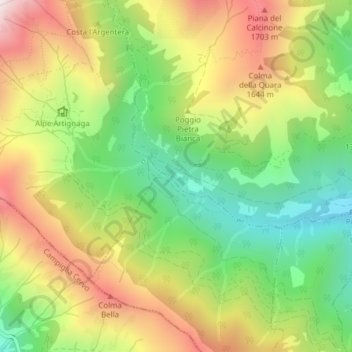
Name: Alpe Rondolere topographic map, elevation, terrain.

Location: Alpe Rondolere, Bioglio, Biella, Piemonte, 13812, Italia (45.66791 8.03425 45.68791 8.05425)

Average elevation: 1,409 m

Minimum elevation: 1,051 m

Maximum elevation: 1,842 m

Gear up for your next adventure:

🔭Compact Monocular - One-handed bird watching and trail spotting
💧Collapsible Water Bottle - Space-saving water bottle for outdoor activities
🧤Rechargeable Heated Gloves - Extreme warmth for Canadian winter expeditions
🎒Hiking Backpack - Lightweight and ergonomic backpacks for day hikes or multi-day treks
🧢Hiking Sun Hat - Wide-brimmed protection for exposed mountain ridges

As an Amazon Associate, this site earns from qualifying purchases at no extra cost to you.