Geolocate

Tūrangi topographic map

Click on the map to display elevation.

About this map

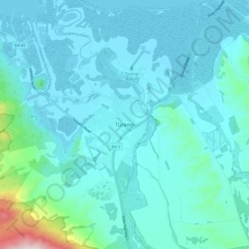
Name: Tūrangi topographic map, elevation, terrain.

Location: Tūrangi, Taupō District, Waikato, 3334, New Zealand (-39.02873 175.76895 -38.94873 175.84895)

Average elevation: 417 m

Minimum elevation: 354 m

Maximum elevation: 922 m

Other topographic maps

Click on a map to view its topography, its elevation and its terrain.

Hauhungaroa Range

New Zealand > Waikato > Taupo District

Average elevation: 753 m

Tongariro River

New Zealand > Waikato > Taupo District

Average elevation: 853 m

Lake Rotoaira

New Zealand > Waikato > Taupo District

Average elevation: 624 m

Lake Rotokawa

New Zealand > Waikato > Taupo District

Average elevation: 358 m

Lake Rotopounamu

New Zealand > Waikato > Taupo District

Average elevation: 784 m

Summit Plateau

New Zealand > Waikato > Taupo District

Average elevation: 2,454 m

Motutaiko Island

New Zealand > Waikato > Taupo District

Average elevation: 357 m

Gear up for your next adventure:

🔭Compact Binoculars - Lightweight optics for scouting trails and wildlife
💡Compact LED Flashlight - Powerful and portable flashlight for outdoor use
🧼Biodegradable Camp Soap - Environmentally friendly cleaning for gear and body
💡Portable Camping Lamp - Rechargeable lamp for campsite lighting
💡LED Camping Lantern - Illuminate your campsite with long-lasting lanterns

As an Amazon Associate, this site earns from qualifying purchases at no extra cost to you.