
Thank you for supporting this site ❤️
Make a donation
Make a donation
Gear up for your next adventure:
As an Amazon Associate, this site earns from qualifying purchases at no extra cost to you.
Wiesenbronn topographic map
Click on the map to display elevation.
Thank you for supporting this site ❤️
Make a donation
Make a donation
Gear up for your next adventure:
As an Amazon Associate, this site earns from qualifying purchases at no extra cost to you.
Wiesenbronn
Naturräumlich liegt Wiesenbronn im Schwanbergvorland, einem Teil des Steigerwaldvorlandes. Die Landschaft ist durch kleinere Hügel charakterisiert; in Richtung des Steigerwaldes nimmt ihre Höhe zu.
Thank you for supporting this site ❤️
Make a donation
Make a donation
Gear up for your next adventure:
As an Amazon Associate, this site earns from qualifying purchases at no extra cost to you.
About this map
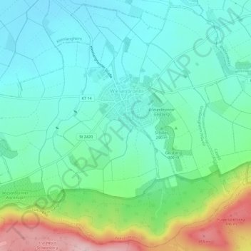
Name: Wiesenbronn topographic map, elevation, terrain.
Average elevation: 296 m
Minimum elevation: 231 m
Maximum elevation: 478 m
Thank you for supporting this site ❤️
Make a donation
Make a donation
Gear up for your next adventure:
As an Amazon Associate, this site earns from qualifying purchases at no extra cost to you.