Geolocate

Badalucco topographic map

Click on the map to display elevation.

About this map

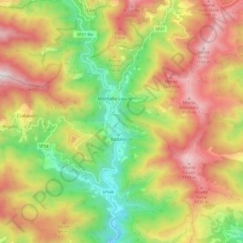
Name: Badalucco topographic map, elevation, terrain.

Location: Badalucco, Provincia di Imperia, Liguria, Italy (43.89866 7.76923 43.94282 7.87034)

Average elevation: 630 m

Minimum elevation: 80 m

Maximum elevation: 1,210 m

Other topographic maps

Click on a map to view its topography, its elevation and its terrain.

Montalto Ligure

Italy > Liguria > Provincia di Imperia

Average elevation: 529 m

Bestagno

Italy > Liguria > Provincia di Imperia > Pontedassio

Average elevation: 274 m

Gear up for your next adventure:

🎒Fully Waterproof Backpack - Total protection for photography gear and electronics
🛌Insulated Sleeping Pad - Critical thermal barrier between you and the cold ground
🧢Outdoor Visor - Breathable visor for sunny hikes
🧢Sun Protection Cap - Breathable cap to protect from sun exposure
Lightweight Backpacking Tent - Compact tent for efficient hiking trips

As an Amazon Associate, this site earns from qualifying purchases at no extra cost to you.