
Thank you for supporting this site ❤️
Make a donation
Make a donation
Gear up for your next adventure:
As an Amazon Associate, this site earns from qualifying purchases at no extra cost to you.
Penobscot topographic map
Click on the map to display elevation.
Thank you for supporting this site ❤️
Make a donation
Make a donation
Gear up for your next adventure:
As an Amazon Associate, this site earns from qualifying purchases at no extra cost to you.
About this map
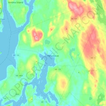
Name: Penobscot topographic map, elevation, terrain.
Location: Penobscot, Hancock County, Maine, 04476, United States (44.39539 -68.80096 44.54083 -68.59945)
Average elevation: 42 m
Minimum elevation: -6 m
Maximum elevation: 150 m
Thank you for supporting this site ❤️
Make a donation
Make a donation
Gear up for your next adventure:
As an Amazon Associate, this site earns from qualifying purchases at no extra cost to you.
Other topographic maps
Click on a map to view its topography, its elevation and its terrain.
Eastern Bay
United States > Maine > Hancock County > Bar Harbor > Salsbury Cove
Average elevation: 9 m