Geolocate

Wan topographic map

Click on the map to display elevation.

About this map

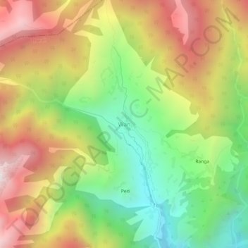
Name: Wan topographic map, elevation, terrain.

Location: Wan, Tharali, Chamoli, Uttarakhand, India (30.18504 79.59753 30.22504 79.63753)

Average elevation: 2,846 m

Minimum elevation: 2,225 m

Maximum elevation: 3,541 m

Other topographic maps

Click on a map to view its topography, its elevation and its terrain.

Tharali

India > Uttarakhand > Tharali

Average elevation: 2,349 m

Kush

India > Uttarakhand > Tharali > Kush

Average elevation: 1,897 m

Gear up for your next adventure:

🥾Light Trekking Boots - Supportive boots for multi-day treks
🥾Trekking Poles - Adjustable trekking poles to reduce knee stress and improve stability
🧊Portable Cooler - Keep food and drinks cold during outdoor adventures
💡Portable Camping Lamp - Rechargeable lamp for campsite lighting
💧Hydration Pack - Hands-free hydration system for long hikes

As an Amazon Associate, this site earns from qualifying purchases at no extra cost to you.