
Make a donation
Gear up for your next adventure:
As an Amazon Associate, this site earns from qualifying purchases at no extra cost to you.
Trabadelo topographic map
Click on the map to display elevation.
Make a donation
Gear up for your next adventure:
As an Amazon Associate, this site earns from qualifying purchases at no extra cost to you.
Trabadelo
In de gemeente liggen de dorpen en gehuchten Moral de Valcarce, Parada de Soto, Pereje, Pradela, San Fiz do Seo, Sotelo, Sotoparada, Villar de Corrales en Trabadelo zelf. De gemeente wordt doorkruist door de Autovía del Noroeste (A-6) en de N-VI. De hoogte van het gebied varieert van 1453 meter (Pico de Loro) op de gemeentegrens met Balboa en Villafranca del Bierzo, in het Sierra de Ancares gebergte, tot 520 meter aan de oevers van de Rio Valcarce. Het dorpscentrum ligt op 590 meter boven de zeespiegel.
Make a donation
Gear up for your next adventure:
As an Amazon Associate, this site earns from qualifying purchases at no extra cost to you.
About this map
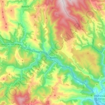
Name: Trabadelo topographic map, elevation, terrain.
Location: Trabadelo, El Bierzo, León, Castilië en León, Spanje (42.59694 -6.94038 42.71326 -6.80516)
Average elevation: 876 m
Minimum elevation: 479 m
Maximum elevation: 1,444 m
Make a donation
Gear up for your next adventure:
As an Amazon Associate, this site earns from qualifying purchases at no extra cost to you.
Other topographic maps
Click on a map to view its topography, its elevation and its terrain.
El Puente de Domingo Flórez / A Ponte
Spanje > Castilië en León > El Bierzo > Puente de Domingo Flórez
Average elevation: 527 m
Make a donation
Gear up for your next adventure:
As an Amazon Associate, this site earns from qualifying purchases at no extra cost to you.
San Fiz do Seo
Spanje > Castilië en León > El Bierzo > Trabadelo > San Fiz do Seo
Average elevation: 782 m