Geolocate

Brixham topographic map

Click on the map to display elevation.

About this map

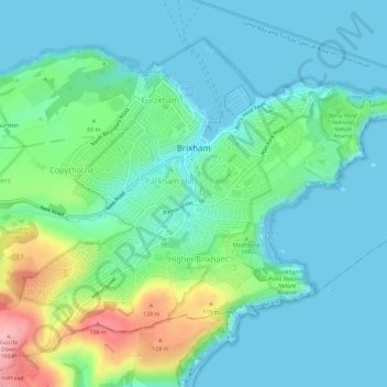
Name: Brixham topographic map, elevation, terrain.

Location: Brixham, Torbay, England, United Kingdom (50.37598 -3.54037 50.40569 -3.48230)

Average elevation: 38 m

Minimum elevation: -1 m

Maximum elevation: 164 m

Gear up for your next adventure:

🚲Heavy Duty Bike Lock - Secure your bike at the trailhead or during stops
💧Reusable Water Bottle - Durable water bottles for hydration on trails
🩹Compact First Aid Kit - Pre-packed essentials for common trail injuries
🔪Outdoor Multitool - Versatile tool for repairs and food prep in the wild
🪜Heavy Duty Carabiners - Multi-use clips for securing gear to your backpack

As an Amazon Associate, this site earns from qualifying purchases at no extra cost to you.