
Make a donation
Gear up for your next adventure:
As an Amazon Associate, this site earns from qualifying purchases at no extra cost to you.
Wehrstapel topographic map
Click on the map to display elevation.
Make a donation
Gear up for your next adventure:
As an Amazon Associate, this site earns from qualifying purchases at no extra cost to you.
About this map
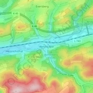
Name: Wehrstapel topographic map, elevation, terrain.
Average elevation: 381 m
Minimum elevation: 261 m
Maximum elevation: 585 m
Make a donation
Gear up for your next adventure:
As an Amazon Associate, this site earns from qualifying purchases at no extra cost to you.
Other topographic maps
Click on a map to view its topography, its elevation and its terrain.
Hennesee
Deutschland > Nordrhein-Westfalen > Hochsauerlandkreis > Meschede > Berghausen
Finanzielle Unterstützung hatte die Genossenschaft durch den 1899 gegründeten Ruhrtalsperrenverein (RTV) erhalten, der das Projekt mit jährlich 110.000 Mark förderte, um dadurch dem Wassermangel an der unteren Ruhr und im Ruhrgebiet abzuhelfen. Als Gegenleistung konnte der RTV bei Bedarf eine Abgabe von…
Average elevation: 381 m