
Make a donation
Gear up for your next adventure:
As an Amazon Associate, this site earns from qualifying purchases at no extra cost to you.
Karlsruhe topographic map
Click on the map to display elevation.
Make a donation
Gear up for your next adventure:
As an Amazon Associate, this site earns from qualifying purchases at no extra cost to you.
Karlsruhe
The city lies at an altitude of between 100 and 322 m (328 and 1,056 ft), the higher figure being near the communications tower in the suburb of Grünwettersbach. Its geographical coordinates are 49°00′N 8°24′E / 49.000°N 8.400°E / 49.000; 8.400; the 49th parallel runs through the city centre, which puts it at the same latitude as much of the Canada–United States border and the cities of Vancouver (Canada), Paris (France), Regensburg (Germany), and Hulunbuir (China). Its course is marked by a stone and painted line in the Stadtgarten (municipal park). The total area of the city is 173.46 km2 (66.97 sq mi), hence it is the 30th largest city in Germany measured by land area. The longest north–south distance is 16.8 km (10.4 mi) and 19.3 km (12.0 mi) in the east–west direction.
Make a donation
Gear up for your next adventure:
As an Amazon Associate, this site earns from qualifying purchases at no extra cost to you.
About this map
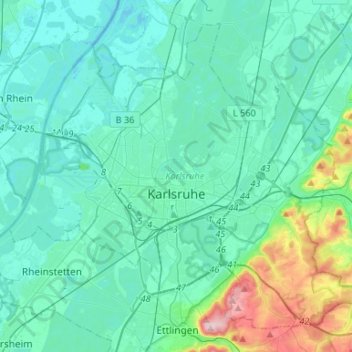
Name: Karlsruhe topographic map, elevation, terrain.
Location: Karlsruhe, Baden-Württemberg, Germany (48.94047 8.27731 49.09128 8.54173)
Average elevation: 132 m
Minimum elevation: 94 m
Maximum elevation: 349 m
Make a donation
Gear up for your next adventure:
As an Amazon Associate, this site earns from qualifying purchases at no extra cost to you.