Geolocate

Langkawi topographic map

Click on the map to display elevation.

About this map

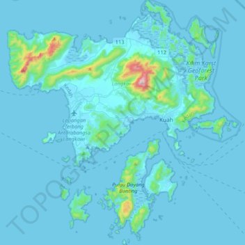
Name: Langkawi topographic map, elevation, terrain.

Location: Langkawi, Kedah, Malaysia (6.15617 99.64050 6.47759 99.94545)

Average elevation: 40 m

Minimum elevation: -2 m

Maximum elevation: 859 m

Other topographic maps

Click on a map to view its topography, its elevation and its terrain.

Pregnant Maiden Lake

Malaysia > Kedah

Average elevation: 147 m

Seven Wells Waterfall

Malaysia > Kedah

Average elevation: 246 m

Sungai Petani

Malaysia > Kedah > Sungai Petani

Average elevation: 45 m

Kampung Tok Weng

Malaysia > Kedah > Baling

Average elevation: 115 m

Oriental Village

Malaysia > Kedah > Oriental Village

Average elevation: 130 m

Kulim

Malaysia > Kedah > Kulim

Average elevation: 54 m

Kampung Kelubi Dalam

Malaysia > Kedah

Average elevation: 38 m

Gear up for your next adventure:

🥾Waterproof Trail Shoes - Shoes designed to handle wet terrain
Camping Tent - Weather-resistant tents suitable for 2 to 6 people
🧭Orienteering Kit - Tools for map reading and navigation in the wild
🪜Heavy Duty Carabiners - Multi-use clips for securing gear to your backpack
🍽️Titanium Camping Spork - Ultralight and indestructible eating utensil

As an Amazon Associate, this site earns from qualifying purchases at no extra cost to you.