Geolocate

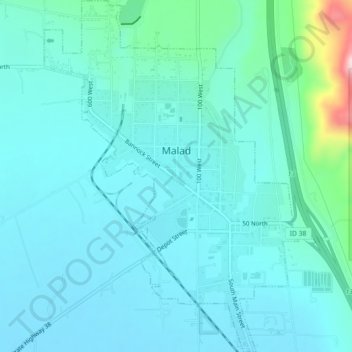
Malad City topographic map

Click on the map to display elevation.

Malad City

According to the United States Census Bureau, the city has a total area of 1.66 square miles (4.30 km2), all of it land. It lies on the eastern edge of Malad Valley at 4,540 feet (1,380 m) in elevation.

Wikipedia (CC-BY-SA 3.0)

About this map

Name: Malad City topographic map, elevation, terrain.

Location: Malad City, Oneida County, Idaho, United States (42.17254 -112.26765 42.20570 -112.23513)

Average elevation: 1,406 m

Minimum elevation: 1,365 m

Maximum elevation: 1,653 m

Other topographic maps

Click on a map to view its topography, its elevation and its terrain.
Samaria

United States > Idaho > Oneida County

Average elevation: 1,378 m

Malad Summit

United States > Idaho > Oneida County

Average elevation: 1,715 m

Gear up for your next adventure:

🎒Backpack Rain Cover - External shield to keep your entire pack dry
🌬️Windproof Camp Stove - Efficient cooking even on exposed mountain peaks
🔦UV Flashlight - Detect minerals or specific insects in the dark
🛰️Satellite Messenger - Emergency communication for areas with no cell service
🛌Insulated Sleeping Pad - Critical thermal barrier between you and the cold ground

As an Amazon Associate, this site earns from qualifying purchases at no extra cost to you.