
Thank you for supporting this site ❤️
Make a donation
Make a donation
Gear up for your next adventure:
As an Amazon Associate, this site earns from qualifying purchases at no extra cost to you.
Yenkepalle topographic map
Click on the map to display elevation.
Thank you for supporting this site ❤️
Make a donation
Make a donation
Gear up for your next adventure:
As an Amazon Associate, this site earns from qualifying purchases at no extra cost to you.
About this map
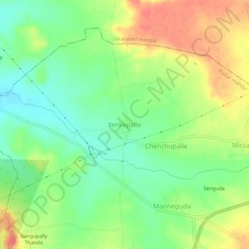
Name: Yenkepalle topographic map, elevation, terrain.
Location: Yenkepalle, Pudur mandal, Vikarabad, Telangana, India (17.29145 77.95334 17.33145 77.99334)
Average elevation: 664 m
Minimum elevation: 639 m
Maximum elevation: 693 m
Thank you for supporting this site ❤️
Make a donation
Make a donation
Gear up for your next adventure:
As an Amazon Associate, this site earns from qualifying purchases at no extra cost to you.