
Make a donation
Gear up for your next adventure:
As an Amazon Associate, this site earns from qualifying purchases at no extra cost to you.
Tipaturu topographic map
Click on the map to display elevation.
Make a donation
Gear up for your next adventure:
As an Amazon Associate, this site earns from qualifying purchases at no extra cost to you.
Tipaturu
Tiptur has been surrounded by from the west side Arsikere and channarayapatna. from the east side Chikkanayakana halli, Gubbi, Turuvekere. Tiptur is approximately 73 km (45 mi) west of Tumkur along National Highway 206 (now renumbered as National Highway 48). It is at a distance of 140 km (87 mi) northwest from the state capital, Bangalore. It lies on the Bangalore-Miraj railway line. Tiptur has an average elevation of 861 metres (2,825 ft). The average temperature in summer is 34 °C (93 °F) and in winter is 20 °C (68 °F).
Make a donation
Gear up for your next adventure:
As an Amazon Associate, this site earns from qualifying purchases at no extra cost to you.
About this map
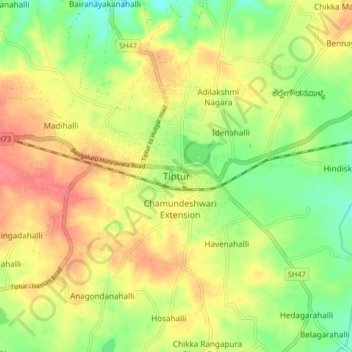
Name: Tipaturu topographic map, elevation, terrain.
Location: Tipaturu, Tipaturu taluk, Tumakuru, Karnataka, 572200, India (13.21858 76.43377 13.29858 76.51377)
Average elevation: 855 m
Minimum elevation: 823 m
Maximum elevation: 886 m
Make a donation
Gear up for your next adventure:
As an Amazon Associate, this site earns from qualifying purchases at no extra cost to you.