Geolocate

Westover topographic map

Click on the map to display elevation.

About this map

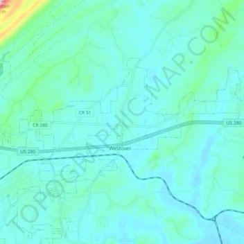
Name: Westover topographic map, elevation, terrain.

Location: Westover, Shelby County, Alabama, 35147, United States (33.30996 -86.58713 33.42235 -86.47822)

Average elevation: 177 m

Minimum elevation: 126 m

Maximum elevation: 459 m

Other topographic maps

Click on a map to view its topography, its elevation and its terrain.

Hoover

United States > Alabama > Shelby County > Hoover

Average elevation: 238 m

Chelsea

United States > Alabama > Shelby County > Chelsea

Average elevation: 213 m

Helena

United States > Alabama > Shelby County

Average elevation: 156 m

Calera

United States > Alabama > Shelby County

Average elevation: 173 m

Westover

United States > Alabama > Shelby County

Average elevation: 153 m

Pelham

United States > Alabama > Shelby County > Pelham > Pelham

Average elevation: 164 m

Chelsea

United States > Alabama > Shelby County

Average elevation: 171 m

Helena

United States > Alabama > Shelby County > Helena > Helena

Average elevation: 156 m

Calera

United States > Alabama > Shelby County > Calera > Calera

Average elevation: 168 m

Lawley

United States > Alabama > Shelby County > Lawley

Average elevation: 168 m

Arkwright

United States > Alabama > Shelby County > Vincent

Average elevation: 137 m

Gear up for your next adventure:

🪑Ultralight Camping Stool - Compact seating for rest stops during long hikes
🩹Compact First Aid Kit - Pre-packed essentials for common trail injuries
🛁Quick-Dry Microfiber Towel - Space-saving towel that dries rapidly on the move
🧤Thermal Hiking Gloves - Grip-enhanced gloves for cold-weather altitude trekking
🧥Ultralight Puffy Jacket - Maximum warmth that packs down to the size of an orange

As an Amazon Associate, this site earns from qualifying purchases at no extra cost to you.