Geolocate

Kanthkot topographic map

Click on the map to display elevation.

About this map

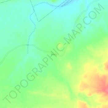
Name: Kanthkot topographic map, elevation, terrain.

Location: Kanthkot, Bhachau Taluka, Kachchh, Gujarat, 370135, India (23.48514 70.48696 23.52514 70.52696)

Average elevation: 100 m

Minimum elevation: 73 m

Maximum elevation: 149 m

Other topographic maps

Click on a map to view its topography, its elevation and its terrain.

Khadir Bet

India > Gujarat > Bhachau Taluka

Average elevation: 14 m

Gear up for your next adventure:

🥤Collapsible Travel Cup - Saves space and weight in your mess kit
🧥Packable Rain Jacket - Breathable waterproof layer for unpredictable weather
🔭Outdoor Binoculars - Lightweight binoculars for birdwatching and hiking
🥾Lightweight Hiking Shoes - Comfortable shoes for day hikes
🥾Approach Shoes - Shoes designed for climbing approaches and rugged trails

As an Amazon Associate, this site earns from qualifying purchases at no extra cost to you.