
Make a donation
Gear up for your next adventure:
As an Amazon Associate, this site earns from qualifying purchases at no extra cost to you.
Santa Rosa topographic map
Click on the map to display elevation.
Make a donation
Gear up for your next adventure:
As an Amazon Associate, this site earns from qualifying purchases at no extra cost to you.
About this map
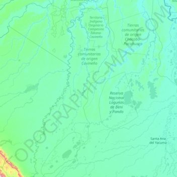
Name: Santa Rosa topographic map, elevation, terrain.
Location: Santa Rosa, General José Ballivián Segurola, Beni, Bolivia (-14.35097 -66.99671 -11.41170 -66.24439)
Average elevation: 167 m
Minimum elevation: 121 m
Maximum elevation: 1,604 m
Make a donation
Gear up for your next adventure:
As an Amazon Associate, this site earns from qualifying purchases at no extra cost to you.
Other topographic maps
Click on a map to view its topography, its elevation and its terrain.
San Juan Baltazar
Bolivia > Beni > General José Ballivián Segurola > Rurrenabaque
Average elevation: 243 m
Make a donation
Gear up for your next adventure:
As an Amazon Associate, this site earns from qualifying purchases at no extra cost to you.
El Cebu
Bolivia > Beni > General José Ballivián Segurola > Rurrenabaque > El Cebu
Average elevation: 240 m
Make a donation
Gear up for your next adventure:
As an Amazon Associate, this site earns from qualifying purchases at no extra cost to you.