Geolocate

Grand Ledge topographic map

Click on the map to display elevation.

About this map

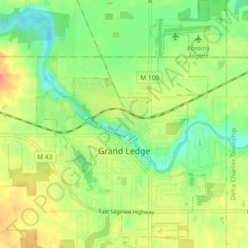
Name: Grand Ledge topographic map, elevation, terrain.

Location: Grand Ledge, Eaton County, Michigan, United States (42.73388 -84.76908 42.78112 -84.71978)

Average elevation: 259 m

Minimum elevation: 239 m

Maximum elevation: 281 m

Other topographic maps

Click on a map to view its topography, its elevation and its terrain.

Lake Interstate

United States > Michigan > Eaton County

Average elevation: 267 m

West Windsor

United States > Michigan > Eaton County

Average elevation: 277 m

Gear up for your next adventure:

Tent Footprint - Protect tent floor and increase durability
🦶Hiking Shoe Insoles - Added support for high arches and long days on feet
🏕️Camping Hammock - Integrated protection for sleeping between trees
🧥Waterproof Hiking Jacket - Protect yourself from rain and wind while hiking
🥾Trail Running Boots - Durable shoes designed for trail running

As an Amazon Associate, this site earns from qualifying purchases at no extra cost to you.