Geolocate

Eschenstruth topographic map

Click on the map to display elevation.

About this map

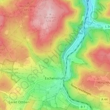
Name: Eschenstruth topographic map, elevation, terrain.

Location: Eschenstruth, Helsa, Landkreis Kassel, Hesse, Germany (51.21610 9.62381 51.25502 9.68513)

Average elevation: 403 m

Minimum elevation: 262 m

Maximum elevation: 541 m

Gear up for your next adventure:

🔭Compact Monocular - One-handed bird watching and trail spotting
💡LED Camping Lantern - Illuminate your campsite with long-lasting lanterns
🧢Sun Hat - Wide-brim hat for sun protection
🧢Hiking Hat - Sun-protective and breathable hats for long treks
🦶Anti-Blister Balm - Prevents friction and hotspots during long ascents

As an Amazon Associate, this site earns from qualifying purchases at no extra cost to you.