
Thank you for supporting this site ❤️
Make a donation
Make a donation
Gear up for your next adventure:
As an Amazon Associate, this site earns from qualifying purchases at no extra cost to you.
Tordenaso topographic map
Click on the map to display elevation.
Thank you for supporting this site ❤️
Make a donation
Make a donation
Gear up for your next adventure:
As an Amazon Associate, this site earns from qualifying purchases at no extra cost to you.
About this map
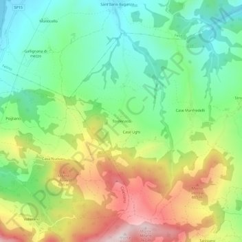
Name: Tordenaso topographic map, elevation, terrain.
Location: Tordenaso, Langhirano, Parma, Emilia-Romagna, 43013, Italia (44.61418 10.19071 44.65418 10.23071)
Average elevation: 457 m
Minimum elevation: 266 m
Maximum elevation: 760 m
Thank you for supporting this site ❤️
Make a donation
Make a donation
Gear up for your next adventure:
As an Amazon Associate, this site earns from qualifying purchases at no extra cost to you.