Geolocate

Varkala topographic map

Click on the map to display elevation.

About this map

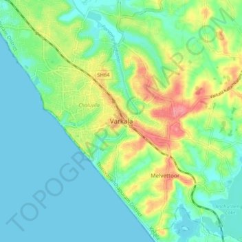
Name: Varkala topographic map, elevation, terrain.

Location: Varkala, Thiruvananthapuram, Kerala, 695145, India (8.69404 76.68529 8.77404 76.76529)

Average elevation: 23 m

Minimum elevation: 0 m

Maximum elevation: 78 m

Other topographic maps

Click on a map to view its topography, its elevation and its terrain.

Varkkala

India > Kerala > Varkala > Varkala

Average elevation: 29 m

Gear up for your next adventure:

🛶Kayak Dry Bag - Waterproof storage for kayaking adventures
👟Trail Running Shoes - Agile footwear for fast-paced topographic exploration
💧Hydration Bladder - Hands-free hydration solution for long treks
🧴Sunscreen SPF - Broad-spectrum sunscreen for outdoor activities
🎒Hiking Backpack - Lightweight and ergonomic backpacks for day hikes or multi-day treks

As an Amazon Associate, this site earns from qualifying purchases at no extra cost to you.