
Thank you for supporting this site ❤️
Make a donation
Make a donation
Gear up for your next adventure:
As an Amazon Associate, this site earns from qualifying purchases at no extra cost to you.
Carcente topographic map
Click on the map to display elevation.
Thank you for supporting this site ❤️
Make a donation
Make a donation
Gear up for your next adventure:
As an Amazon Associate, this site earns from qualifying purchases at no extra cost to you.
About this map
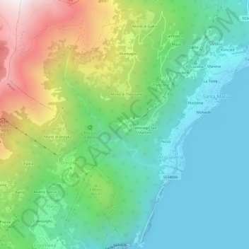
Name: Carcente topographic map, elevation, terrain.
Location: Carcente, Acquaseria, San Siro, Como, Lombardy, 22010, Italy (46.03952 9.22695 46.07952 9.26695)
Average elevation: 693 m
Minimum elevation: 190 m
Maximum elevation: 1,833 m
Thank you for supporting this site ❤️
Make a donation
Make a donation
Gear up for your next adventure:
As an Amazon Associate, this site earns from qualifying purchases at no extra cost to you.