
Watermillock topographic map
Interactive map
Click on the map to display elevation.
About this map
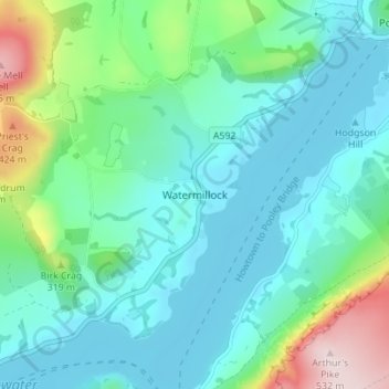
Name: Watermillock topographic map, elevation, terrain.
Location: Watermillock, Eden, Cumbria, Angleterre, CA11 0JH, Royaume-Uni (54.57464 -2.87989 54.61464 -2.83989)
Average elevation: 227 m
Minimum elevation: 144 m
Maximum elevation: 531 m
Other topographic maps
Click on a map to view its topography, its elevation and its terrain.
Howsteadbrow
Royaume-Uni > Angleterre > Cumbria > Eden > Howsteadbrow
Howsteadbrow, Martindale, Eden, Cumbria, Angleterre du Nord-Ouest, Angleterre, CA10 2NF, Royaume-Uni
Average elevation: 284 m