
Make a donation
Gear up for your next adventure:
As an Amazon Associate, this site earns from qualifying purchases at no extra cost to you.
Gösselborn topographic map
Click on the map to display elevation.
Make a donation
Gear up for your next adventure:
As an Amazon Associate, this site earns from qualifying purchases at no extra cost to you.
Gösselborn
Gösselborn liegt auf der Ilm-Saale-Platte in etwa 460 Metern Höhe, rund sieben Kilometer südlich von Stadtilm. Östlich des Dorfs erhebt sich der 545 Meter hohe Herrenberg, westlich liegt das Mahlholz (502 m), im Süden beginnt das Rottenbach-Tal und im Norden erstreckt sich das Kopptal. Nachbardörfer sind Geilsdorf im Norden, Hengelbach im Osten, Paulinzella im Süden und Singen im Westen.
Make a donation
Gear up for your next adventure:
As an Amazon Associate, this site earns from qualifying purchases at no extra cost to you.
About this map
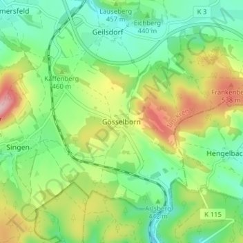
Name: Gösselborn topographic map, elevation, terrain.
Location: Gösselborn, Stadtilm, Ilm-Kreis, Thüringen, 99326, Deutschland (50.70942 11.06322 50.74942 11.10322)
Average elevation: 452 m
Minimum elevation: 382 m
Maximum elevation: 576 m
Make a donation
Gear up for your next adventure:
As an Amazon Associate, this site earns from qualifying purchases at no extra cost to you.