
Make a donation
Gear up for your next adventure:
As an Amazon Associate, this site earns from qualifying purchases at no extra cost to you.
Pitarque topographic map
Click on the map to display elevation.
Make a donation
Gear up for your next adventure:
As an Amazon Associate, this site earns from qualifying purchases at no extra cost to you.
About this map
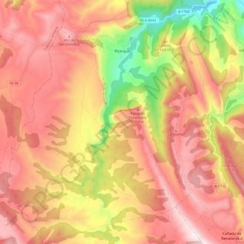
Name: Pitarque topographic map, elevation, terrain.
Location: Pitarque, Maestrazgo, Teruel, Aragón, 44555, España (40.57604 -0.65159 40.66761 -0.55453)
Average elevation: 1,320 m
Minimum elevation: 845 m
Maximum elevation: 1,629 m
Make a donation
Gear up for your next adventure:
As an Amazon Associate, this site earns from qualifying purchases at no extra cost to you.
Other topographic maps
Click on a map to view its topography, its elevation and its terrain.
Make a donation
Gear up for your next adventure:
As an Amazon Associate, this site earns from qualifying purchases at no extra cost to you.
Luco de Bordón
España > Aragón > Maestrazgo > Castellote
Luco de Bordón se encuentra a 811 metros de altitud en la Sierra de Bordón, a 154 km de distancia de la capital provincial (Teruel), su término es limítrofe con la Comunidad Valenciana. Comunicado con el municipio de Villores por la carretera CV-119 (provincia de Castellón) y TE-8402 (provincia de Teruel)…
Average elevation: 847 m