Geolocate

Cannington topographic map

Click on the map to display elevation.

About this map

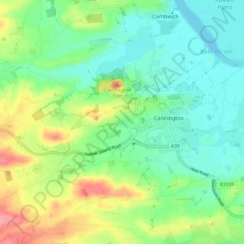
Name: Cannington topographic map, elevation, terrain.

Location: Cannington, Somerset, England, United Kingdom (51.12622 -3.11622 51.17445 -3.03098)

Average elevation: 29 m

Minimum elevation: -2 m

Maximum elevation: 88 m

Other topographic maps

Click on a map to view its topography, its elevation and its terrain.

Charlton Mackrell

United Kingdom > England > Somerset

Average elevation: 42 m

Ludney

United Kingdom > England > Somerset > Kingstone

Average elevation: 89 m

Highbridge

United Kingdom > England > Somerset > Sedgemoor > Highbridge

Average elevation: 6 m

Burnham-on-Sea

United Kingdom > England > Somerset > Sedgemoor

Average elevation: 5 m

Draycott

United Kingdom > England > Somerset > Mendip District > Draycott

Average elevation: 86 m

Gear up for your next adventure:

🥾Mountain Trail Shoes - High-traction shoes for mountain trails
💧Hydration Bladder - Hands-free hydration solution for long treks
🛶Kayak Dry Bag - Waterproof storage for kayaking adventures
🔦LED Headlamp - Hands-free lighting for early morning starts or late finishes
🧢Hiking Sun Hat - Wide-brimmed protection for exposed mountain ridges

As an Amazon Associate, this site earns from qualifying purchases at no extra cost to you.