Geolocate

Highcroft topographic map

Click on the map to display elevation.

About this map

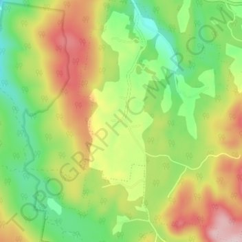
Name: Highcroft topographic map, elevation, terrain.

Location: Highcroft, Tasman, Tasmania, Australia (-43.17579 147.75119 -43.13098 147.80421)

Average elevation: 163 m

Minimum elevation: 34 m

Maximum elevation: 333 m

Other topographic maps

Click on a map to view its topography, its elevation and its terrain.

Tasman Island

Australia > Tasmania > Tasman

Average elevation: 19 m

Cape Pillar

Australia > Tasmania > Tasman

Average elevation: 18 m

Simmonds Hill

Australia > Tasmania > Tasman

Average elevation: 189 m

White Beach

Australia > Tasmania > Tasman > White Beach

Average elevation: 45 m

Gear up for your next adventure:

🧭GPS Outdoor Watch - Smart watch for navigation and fitness tracking in nature
🥾Mountaineering Boots - Supportive boots for climbing and high-altitude hiking
👖Convertible Hiking Pants - Zip-off legs to adapt to changing weather conditions
❄️Traction Ice Cleats - Slip-on spikes for icy trails and winter hiking
Tent Footprint - Protect tent floor and increase durability

As an Amazon Associate, this site earns from qualifying purchases at no extra cost to you.