
Αγιόκαμπος topographic map
Interactive map
Click on the map to display elevation.
About this map
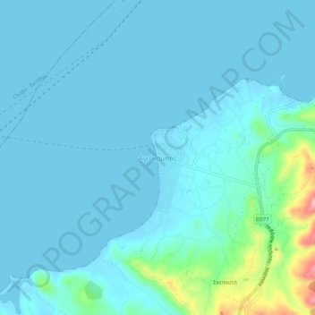
Name: Αγιόκαμπος topographic map, elevation, terrain.
Average elevation: 16 m
Minimum elevation: -2 m
Maximum elevation: 142 m
Other topographic maps
Click on a map to view its topography, its elevation and its terrain.
Κύμη
Grèce > Thessalie-Grèce centrale > Περιφερειακή Ενότητα Ευβοίας
Κύμη, Δήμος Κύμης - Αλιβερίου, Περιφερειακή Ενότητα Ευβοίας, Grèce-Centrale, Thessalie-Grèce centrale, 340 03, Grèce
Average elevation: 195 m
Profitis Ilias
Grèce > Thessalie-Grèce centrale > Περιφερειακή Ενότητα Ευβοίας > Chalcis > Profitis Ilias
Profitis Ilias, Chalcis, Δήμος Χαλκιδέων, Περιφερειακή Ενότητα Ευβοίας, Grèce-Centrale, Thessalie-Grèce centrale, 341 00, Grèce
Average elevation: 276 m
Φαράκλα
Grèce > Thessalie-Grèce centrale > Περιφερειακή Ενότητα Ευβοίας
Φαράκλα, Δήμος Μαντουδίου - Λίμνης - Αγίας Άννας, Περιφερειακή Ενότητα Ευβοίας, Grèce-Centrale, Thessalie-Grèce centrale, 340 04, Grèce
Average elevation: 100 m