Geolocate

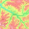
Trois-Rivières topographic map

Click on the map to display elevation.

About this map

Name: Trois-Rivières topographic map, elevation, terrain.

Location: Trois-Rivières, Montdidier, Somme, Hauts-de-France, Metropolitan France, 80500, France (49.68980 2.49591 49.73797 2.58579)

Average elevation: 83 m

Minimum elevation: 36 m

Maximum elevation: 120 m

Other topographic maps

Click on a map to view its topography, its elevation and its terrain.

Petit-Camon

France > Hauts-de-France > Somme > Camon

Average elevation: 73 m

Amiens

France > Hauts-de-France > Somme > Amiens

Average elevation: 86 m

Larronville

France > Hauts-de-France > Somme > Rue

Average elevation: 8 m

Gear up for your next adventure:

⛺Camping Groundsheet - Protect your tent from moisture and dirt
🧳Compression Sacks - Maximize space in your backpack by shrinking gear
🥾Light Trekking Boots - Supportive boots for multi-day treks
🧦Thermal Socks - Warm socks for winter hiking or camping
🔥Emergency Fire Starter - Reliable ignition source for all weather conditions

As an Amazon Associate, this site earns from qualifying purchases at no extra cost to you.