Geolocate

Mount Amiata topographic map

Click on the map to display elevation.

Mount Amiata

The region is included in the comuni of Abbadia San Salvatore, Arcidosso, Castel del Piano, Piancastagnaio, Santa Fiora and Seggiano, all located between 600 and 800 metres of altitude.

Wikipedia (CC-BY-SA 3.0)

About this map

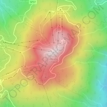
Name: Mount Amiata topographic map, elevation, terrain.

Location: Mount Amiata, Abbadia San Salvatore, Unione dei Comuni Amiata Val d'Orcia, Siena, Tuscany, 53021, Italy (42.88738 11.62322 42.88748 11.62332)

Average elevation: 1,425 m

Minimum elevation: 1,118 m

Maximum elevation: 1,717 m

Gear up for your next adventure:

🐕Hiking Dog Pack - Let your canine companion carry their own water and food
💡LED Headlamp - Hands-free illumination for night hiking and camping
🧥Waterproof Pants - Keep dry during rainy hiking conditions
🧥Insulated Jacket - Keep warm in cold outdoor conditions
🧥Packable Rain Jacket - Breathable waterproof layer for unpredictable weather

As an Amazon Associate, this site earns from qualifying purchases at no extra cost to you.