
Make a donation
Gear up for your next adventure:
As an Amazon Associate, this site earns from qualifying purchases at no extra cost to you.
Koran va Monjan topographic map
Click on the map to display elevation.
Make a donation
Gear up for your next adventure:
As an Amazon Associate, this site earns from qualifying purchases at no extra cost to you.
Koran va Monjan
Owing to its altitude, Kuran wa Munjan features a subarctic climate (Dsc) bordering on a tundra climate (ET) under the Köppen climate classification. It has brief, pleasant summers and very cold, snowy winters. Winters are extremely long with below-freezing months from October until May. Summers are very short and the seasonal lag prevailed as August is the warmest month of the year with an average temperature of 10.1 °C (50.2 °F). The coldest month January has an average temperature of −17.2 °C (1.0 °F).
Make a donation
Gear up for your next adventure:
As an Amazon Associate, this site earns from qualifying purchases at no extra cost to you.
About this map
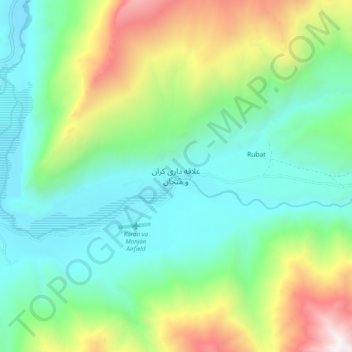
Name: Koran va Monjan topographic map, elevation, terrain.
Average elevation: 3,132 m
Minimum elevation: 2,471 m
Maximum elevation: 4,724 m
Make a donation
Gear up for your next adventure:
As an Amazon Associate, this site earns from qualifying purchases at no extra cost to you.