
Make a donation
Gear up for your next adventure:
As an Amazon Associate, this site earns from qualifying purchases at no extra cost to you.
Stadtilm topographic map
Click on the map to display elevation.
Make a donation
Gear up for your next adventure:
As an Amazon Associate, this site earns from qualifying purchases at no extra cost to you.
Stadtilm
Im Dezember 1918 – kurz nach Ende des Krieges – wurde zum ersten Mal Stadtilmer Notgeld in Umlauf gebracht, zunächst nur 5- und 10-Pfennig-Scheine, später auch 50-Pfennig-Scheine. 1923, zum Höhepunkt der Inflation, entsprachen 10 Milliarden Mark Notgeld 1 Pfennig in Goldmark.
Make a donation
Gear up for your next adventure:
As an Amazon Associate, this site earns from qualifying purchases at no extra cost to you.
About this map
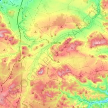
Name: Stadtilm topographic map, elevation, terrain.
Location: Stadtilm, Ilm-Kreis, Thüringen, 99326, Deutschland (50.69417 10.98192 50.82104 11.22411)
Average elevation: 412 m
Minimum elevation: 265 m
Maximum elevation: 578 m
Make a donation
Gear up for your next adventure:
As an Amazon Associate, this site earns from qualifying purchases at no extra cost to you.