Geolocate

Hinode topographic map

Click on the map to display elevation.

About this map

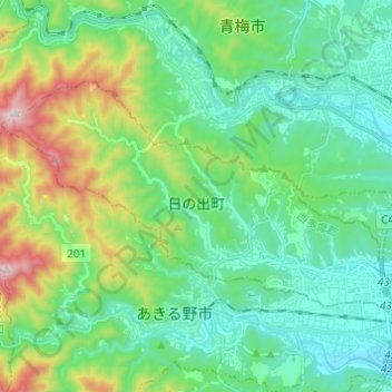
Name: Hinode topographic map, elevation, terrain.

Location: Hinode, Nishitama District, Tokyo, Japan (35.73136 139.16304 35.78919 139.28469)

Average elevation: 313 m

Minimum elevation: 125 m

Maximum elevation: 871 m

Gear up for your next adventure:

🛌Down Sleeping Bag - Superior warmth-to-weight ratio for cold nights
🧥Thermal Layer - Insulating layer for cold outdoor conditions
🪜Heavy Duty Carabiners - Multi-use clips for securing gear to your backpack
🧢Outdoor Cap - Protective cap for sun and rain during hikes
🧥Thermal Fleece Jacket - Versatile insulation for changing mountain temperatures

As an Amazon Associate, this site earns from qualifying purchases at no extra cost to you.