Geolocate

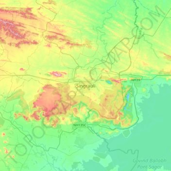
Singrauli topographic map

Click on the map to display elevation.

Singrauli

Singrauli is located on 24°12′07″N 82°39′58″E / 24.202°N 82.666°E / 24.202; 82.666. It is at an elevation of 394 m. 486889 is pin code of singrauli.

Wikipedia (CC-BY-SA 3.0)

About this map

Name: Singrauli topographic map, elevation, terrain.

Location: Singrauli, Singrauli Tahsil, Singrauli, Madhya Pradesh, 486889, India (24.03744 82.50615 24.35744 82.82615)

Average elevation: 348 m

Minimum elevation: 226 m

Maximum elevation: 633 m

Other topographic maps

Click on a map to view its topography, its elevation and its terrain.

Khairahi

India > Madhya Pradesh > Singrauli Tahsil

Average elevation: 377 m

Podi

India > Madhya Pradesh > Singrauli Tahsil

Average elevation: 303 m

Gear up for your next adventure:

⛺Camping Essentials - All-in-one gear for a comfortable camping trip
🏕️Camping Hammock - Integrated protection for sleeping between trees
💡Portable Camping Lamp - Rechargeable lamp for campsite lighting
🦟Insect Repellent - Keep mosquitoes and black flies away in wooded areas
🥾Trail Hiking Boots - Supportive boots for rough trails

As an Amazon Associate, this site earns from qualifying purchases at no extra cost to you.