
Adare topographic map
Click on the map to display elevation.
About this map
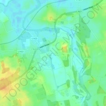
Name: Adare topographic map, elevation, terrain.
Average elevation: 11 m
Minimum elevation: -1 m
Maximum elevation: 32 m
Other topographic maps
Click on a map to view its topography, its elevation and its terrain.
Crecora
Ireland > County Limerick > The Municipal District of Adare — Rathkeale
Average elevation: 37 m
Bleach Lough
Ireland > County Limerick > The Municipal District of Adare — Rathkeale
Average elevation: 10 m
Croom
Ireland > County Limerick > The Municipal District of Adare — Rathkeale > Croom
Average elevation: 34 m
Tory Hill
Ireland > County Limerick > The Municipal District of Adare — Rathkeale
Average elevation: 35 m