
Île Ségal topographic map
Interactive map
Click on the map to display elevation.
About this map
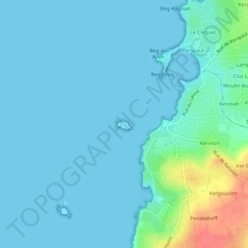
Name: Île Ségal topographic map, elevation, terrain.
Average elevation: 9 m
Minimum elevation: 0 m
Maximum elevation: 61 m
Other topographic maps
Click on a map to view its topography, its elevation and its terrain.
Aber Ildut
Aber Ildut, GR 34, Moulin du Pont Rheun, Plouarzel, Brest, Finistère, Bretagne, France métropolitaine, 29810, France
Average elevation: 21 m
Plage de Kerhornou
Plage de Kerhornou, Route de la Plage de Porsmoguer, Plouarzel, Brest, Finistère, Bretagne, France métropolitaine, 29810, France
Average elevation: 27 m