
Make a donation
Gear up for your next adventure:
As an Amazon Associate, this site earns from qualifying purchases at no extra cost to you.
Pillate topographic map
Click on the map to display elevation.
Make a donation
Gear up for your next adventure:
As an Amazon Associate, this site earns from qualifying purchases at no extra cost to you.
About this map
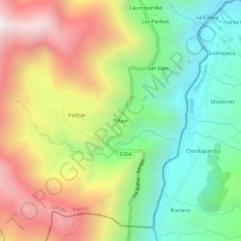
Name: Pillate topographic map, elevation, terrain.
Location: Pillate, Cotalo, Pelileo, Tungurahua, Ecuador (-1.47415 -78.53866 -1.43415 -78.49866)
Average elevation: 2,774 m
Minimum elevation: 2,124 m
Maximum elevation: 3,648 m
Make a donation
Gear up for your next adventure:
As an Amazon Associate, this site earns from qualifying purchases at no extra cost to you.
Other topographic maps
Click on a map to view its topography, its elevation and its terrain.
Pelileo
Ecuador > Tungurahua > Pelileo
Pelileo, también conocida como San Pedro de Pelileo, es una ciudad ecuatoriana; cabecera del cantón Pelileo, así como la tercera urbe más poblada de la Provincia de Tungurahua. Se localiza al centro de la Región interandina del Ecuador, muy próxima al centro geométrico del territorio ecuatoriano; en los…
Average elevation: 2,709 m
Make a donation
Gear up for your next adventure:
As an Amazon Associate, this site earns from qualifying purchases at no extra cost to you.