Geolocate

Ismaning topographic map

Click on the map to display elevation.

About this map

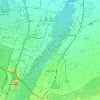
Name: Ismaning topographic map, elevation, terrain.

Location: Ismaning, Landkreis München, Bavaria, 85737, Germany (48.20164 11.64355 48.27898 11.75981)

Average elevation: 485 m

Minimum elevation: 464 m

Maximum elevation: 554 m

Other topographic maps

Click on a map to view its topography, its elevation and its terrain.

Martinsried

Germany > Bavaria > Landkreis München > Planegg

Average elevation: 549 m

Hofolding

Germany > Bavaria > Landkreis München

Average elevation: 609 m

Holzhausen

Germany > Bavaria > Landkreis München

Average elevation: 663 m

Eglfing

Germany > Bavaria > Landkreis München > Haar

Average elevation: 540 m

Deisenhofen

Germany > Bavaria > Landkreis München > Oberhaching

Average elevation: 592 m

Westerham

Germany > Bavaria > Landkreis München > Taufkirchen > Westerham

Average elevation: 565 m

Gear up for your next adventure:

🛌Insulated Sleeping Pad - Critical thermal barrier between you and the cold ground
🧥Ultralight Puffy Jacket - Maximum warmth that packs down to the size of an orange
🚲Handlebar Phone Mount - View topographic-map.com live while cycling
🛶Canoe Life Vest - Safety vest for water sports
🥾Trekking Boots - Durable boots for long-distance trekking

As an Amazon Associate, this site earns from qualifying purchases at no extra cost to you.