Geolocate

A Rañoá topographic map

Click on the map to display elevation.

About this map

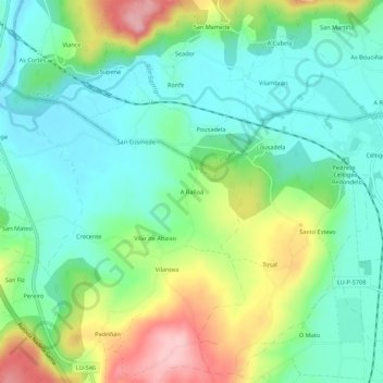
Name: A Rañoá topographic map, elevation, terrain.

Location: A Rañoá, Vilar, Sarria, Lugo, Galicia, 27617, España (42.80957 -7.43495 42.84957 -7.39495)

Average elevation: 429 m

Minimum elevation: 374 m

Maximum elevation: 543 m

Other topographic maps

Click on a map to view its topography, its elevation and its terrain.

Chorente

España > Galicia > Sarria > Sarria

Average elevation: 626 m

Barbadelo

España > Galicia > Sarria > Sarria

Average elevation: 576 m

Ortoá

España > Galicia > Sarria > Sarria

Average elevation: 614 m

Louseiro

España > Galicia > Sarria > Sarria

Average elevation: 507 m

Vilamaior

España > Galicia > Sarria > Sarria

Average elevation: 623 m

Santo André de Paradela

España > Galicia > Sarria > Sarria

Average elevation: 578 m

Fontao

España > Galicia > Sarria > Sarria

Average elevation: 460 m

Gear up for your next adventure:

👖Convertible Hiking Pants - Zip-off legs to adapt to changing weather conditions
📷Outdoor Action Camera - Capture high-elevation views and rugged adventures
🥾Durable Hiking Shoes - Long-lasting shoes for frequent hiking
🚲MTB Frame Bag - Carry tools and maps directly on your bicycle frame
Camping Essentials - All-in-one gear for a comfortable camping trip

As an Amazon Associate, this site earns from qualifying purchases at no extra cost to you.