
Thank you for supporting this site ❤️
Make a donation
Make a donation
Gear up for your next adventure:
As an Amazon Associate, this site earns from qualifying purchases at no extra cost to you.
Sülzhayn topographic map
Click on the map to display elevation.
Thank you for supporting this site ❤️
Make a donation
Make a donation
Gear up for your next adventure:
As an Amazon Associate, this site earns from qualifying purchases at no extra cost to you.
Sülzhayn
Sülzhayn ist ein Stadtteil von Ellrich in Thüringen (Deutschland). Der staatlich anerkannte Erholungsort hat rund 1000 Einwohner und liegt 3 km Luftlinie nordöstlich der Ellricher Stadtmitte auf einer Höhe von 350 m ü. NN.
Thank you for supporting this site ❤️
Make a donation
Make a donation
Gear up for your next adventure:
As an Amazon Associate, this site earns from qualifying purchases at no extra cost to you.
About this map
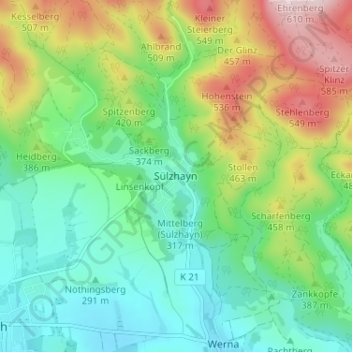
Name: Sülzhayn topographic map, elevation, terrain.
Average elevation: 364 m
Minimum elevation: 241 m
Maximum elevation: 613 m
Thank you for supporting this site ❤️
Make a donation
Make a donation
Gear up for your next adventure:
As an Amazon Associate, this site earns from qualifying purchases at no extra cost to you.