Geolocate

Rijssen topographic map

Click on the map to display elevation.

About this map

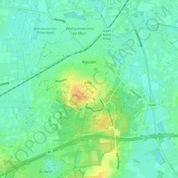
Name: Rijssen topographic map, elevation, terrain.

Location: Rijssen, Rijssen-Holten, Overijssel, Netherlands (52.27186 6.46092 52.32646 6.55401)

Average elevation: 14 m

Minimum elevation: 6 m

Maximum elevation: 35 m

Other topographic maps

Click on a map to view its topography, its elevation and its terrain.

Lemelerberg

Netherlands > Overijssel > Lemele

Average elevation: 19 m

Enschede

Netherlands > Overijssel > Enschede

Average elevation: 34 m

Zuurberg

Netherlands > Overijssel > Holten

Average elevation: 17 m

Frankhuis

Netherlands > Overijssel > Zwolle

Average elevation: 3 m

Witteberg

Netherlands > Overijssel

Average elevation: 57 m

Tankenberg

Netherlands > Overijssel > de Lutte

Average elevation: 58 m

Usselo

Netherlands > Overijssel > Enschede

Average elevation: 31 m

Helhuizen

Netherlands > Overijssel > Holten

Average elevation: 20 m

Gear up for your next adventure:

🧼Travel Hand Sanitizer - Keep hands clean when water is scarce
Camping Groundsheet - Protect your tent from moisture and dirt
🧣Merino Neck Gaiter - Protects against wind, sun, and cold at high altitudes
🥾Trail Hiking Shoes - Durable shoes designed for rugged trails
👟Trail Running Shoes - Agile footwear for fast-paced topographic exploration

As an Amazon Associate, this site earns from qualifying purchases at no extra cost to you.