Geolocate

Luna topographic map

Click on the map to display elevation.

About this map

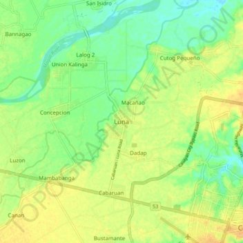
Name: Luna topographic map, elevation, terrain.

Location: Luna, Isabela, Cagayan Valley, Philippines (16.92839 121.68935 17.00839 121.76935)

Average elevation: 53 m

Minimum elevation: 39 m

Maximum elevation: 64 m

Other topographic maps

Click on a map to view its topography, its elevation and its terrain.

Magat Dam

Philippines > Isabela

Average elevation: 176 m

San Guillermo

Philippines > Isabela

Average elevation: 92 m

Gear up for your next adventure:

🧥Softshell Jacket - Windproof and breathable jacket for hiking
🥾Durable Hiking Shoes - Long-lasting shoes for frequent hiking
🛶Canoe Life Vest - Safety vest for water sports
🛏️Sleeping Bag - Warm and compact sleeping bags for outdoor camping
🪑Ultralight Camping Stool - Compact seating for rest stops during long hikes

As an Amazon Associate, this site earns from qualifying purchases at no extra cost to you.